Article 4. Definitions
15.05.410 Words and terms.
The words and phrases used in this chapter shall have the meanings defined below:
“Addition” means any activity that expands the enclosed footprint or increases the square footage of an existing structure.
“Alluvial fan flooding” means a fan-shaped sediment deposit formed by a stream that flows from a steep mountain valley or gorge onto a plain or the junction of a tributary stream with the main stream. Alluvial fans contain active stream channels and boulder bars, and recently abandoned channels. Alluvial fans are predominantly formed by alluvial deposits and are modified by infrequent sheet flood, channel avulsions and other stream processes.
“Area of shallow flooding” means a designated Zone AO or AH on a community’s flood insurance rate map (FIRM) with a one percent (1%) or greater annual chance of flooding to an average depth of one (1') to three feet (3') where a clearly defined channel does not exist, where the path of flooding is unpredictable and where velocity flow may be evident. Such flooding is characterized by ponding or sheet flow.
“Base flood” means the flood which has a one percent (1%) chance of being equaled or exceeded in any given year (also known as a one hundred (100) year flood). This term is used in the National Flood Insurance Program (NFIP) to indicate the minimum level of flooding to be used by a community in its floodplain management regulations.
“Base flood elevation (BFE)” means the elevation shown on a FEMA flood insurance rate map for Zones AE, AH, A1-A30, AR, AR/A, AR/AE, AR/A1-A30, AR/AH, AR/AO, V1-V30, and VE that indicates the water surface elevation resulting from a flood that has a one percent (1%) chance of equaling or exceeding that level in any given year.
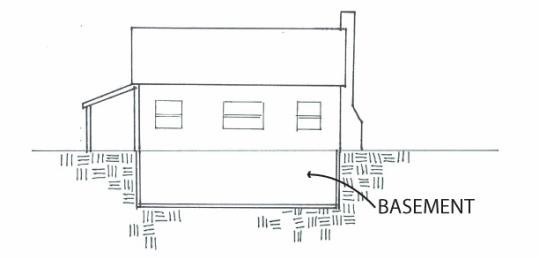
“Basement” means any area of a building having its floor sub-grade (below ground level) on all sides. See Figure 5.1.
Figure 5.1
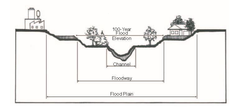
“Channel” means the physical confines of a stream or waterway consisting of a bed and stream banks, existing in a variety of geometries. See Figure 5.2.
“Channelization” means the artificial creation, enlargement or realignment of a stream channel.
“Code of Federal Regulations (CFR)” means the codification of the general and permanent rules published in the Federal Register by the executive departments and agencies of the federal government. It is divided into fifty (50) titles that represent broad areas subject to federal regulation.
“Community” means any political subdivision in the state of Colorado that has authority to adopt and enforce floodplain management regulations through zoning, including, but not limited to, cities, towns, unincorporated areas in the counties, Indian tribes and drainage and flood control districts.
“Critical facility” means a structure or related infrastructure, but not the land on which it is situated, as specified in Rule 6 of the Rules and Regulations for Regulatory Floodplains in Colorado, that if flooded may result in significant hazards to public health and safety or interrupt essential services and operations for the Town at any time before, during and after a flood.
“Development” means any manmade change in improved and unimproved real estate, including but not limited to buildings or other structures, mining, dredging, filling, grading, paving, excavation or drilling operations or storage of equipment or materials.
“DFIRM database” means data and analyses that accompany DFIRMs. The FEMA mapping specifications and guidelines outline requirements for the development and maintenance of DFIRM databases.
“Digital flood insurance rate map (DFIRM)” means a FEMA digital floodplain map. These digital maps serve as “regulatory floodplain maps” for insurance and floodplain management purposes.
“Elevated building” means a nonbasement building (1) built, in the case of a building in Zones A1-30, AE, A, A99, AO, AH, B, C, X, and D, to have the top of the elevated floor above the ground level by means of pilings, columns (posts and piers), or shear walls parallel to the flow of the water and (2) adequately anchored so as not to impair the structural integrity of the building during a flood of up to the magnitude of the base flood. In the case of Zones A1-30, AE, A, A99, AO, AH, B, C, X, and D, “elevated building” also includes a building elevated by means of fill or solid foundation perimeter walls with openings sufficient to facilitate the unimpeded movement of flood waters (See FEMA Lowest Floor Guide).
“Federal Register” means the official daily publication for rules, proposed rules, and notices of federal agencies and organizations, as well as executive orders and other presidential documents.
“FEMA” means Federal Emergency Management Agency, the agency responsible for administering the National Flood Insurance Program.
“Flood” or “flooding” means a general and temporary condition of partial or complete inundation of normally dry land areas from:
1. The overflow of water from channels and reservoir spillways;
2. The unusual and rapid accumulation or runoff of surface waters from any source; or
3. Mudslides or mudflows that occur from excess surface water that is combined with mud or other debris that is sufficiently fluid so as to flow over the surface of normally dry land areas (such as earth carried by a current of water and deposited along the path of the current).
“Flood control structure” means a physical structure designed and built expressly or partially for the purpose of reducing, redirecting, or guiding flood flows along a particular waterway. These specialized flood modifying works are those constructed in conformance with sound engineering standards.
“Flood, five hundred (500) year” means a flood having a recurrence interval that has a two-tenths percent (0.2%) chance of being equaled or exceeded during any given year (two-tenths percent (0.2%) chance annual flood). The term does not imply that the flood will necessarily happen once every five hundred (500) years.
“Flood insurance rate map (FIRM)” means an official map on which the Federal Emergency Management Agency has delineated both the special flood hazard areas and the risk premium zones applicable to the Town.
“Flood insurance study (FIS)” means the official report provided by the Federal Emergency Management Agency. The report contains the flood insurance rate map as well as flood profiles for studied flooding sources that can be used to determine base flood elevations for some areas.
“Flood, one hundred (100) year” means a flood having a recurrence interval that has a one percent (1%) chance of being equaled or exceeded during any given year (one percent (1%) chance annual flood). The terms “one-hundred-year flood” and “one percent (1%) chance flood” are synonymous with the term “one hundred (100) year flood.” The term does not imply that the flood will necessarily happen once every one hundred (100) years.
“Floodplain” or “flood-prone area” means any land area susceptible to being inundated as the result of a flood, including the area of land over which floodwater would flow from the spillway of a reservoir. See Figure 5.2.
“Floodplain Administrator” means the Town official designated by title to administer and enforce the floodplain management regulations.
“Floodplain development permit” means a permit required before construction or development begins within any special flood hazard area (SFHA). If FEMA has not defined the SFHA within the Town, the Town shall require permits for all proposed construction or other development in the Town including the placement of manufactured homes, so that it may determine whether such construction or other development is proposed within flood-prone areas. Permits are required to ensure that proposed development projects meet the requirements of the NFIP and this chapter.
“Floodplain, five hundred (500) year” means the area of land susceptible to being inundated as a result of the occurrence of a five hundred (500) year flood.
“Floodplain, one hundred (100) year” means the area of land susceptible to being inundated as a result of the occurrence of a one hundred (100) year flood.
Figure 5.2
“Floodplain management” means the operation of an overall program of corrective and preventive measures for reducing flood damage, including but not limited to emergency preparedness plans, flood control works and floodplain management regulations.
“Floodplain management regulations” means zoning ordinances, subdivision regulations, building codes, health regulations, special purpose ordinances (such as a floodplain ordinance, grading ordinance and erosion control ordinance) and other applications of police power. The term describes such state or local regulations (including this chapter), in any combination thereof, which provide standards for the purpose of flood damage prevention and reduction.
“Floodproofing” means any combination of structural and/or nonstructural additions, changes, or adjustments to structures which reduce or eliminate flood damage to real estate or improved real property, water and sanitary facilities, structures and their contents.
“Floodway (regulatory floodway)” means the channel of a river or other watercourse and adjacent land areas that must be reserved in order to discharge the base flood without cumulatively increasing the water surface elevation more than a designated height. The Colorado statewide standard for the designated height to be used for all newly studied reaches shall be one-half foot (0.5') (six inches (6")). Letters of map revision to existing floodway delineations may continue to use the floodway criteria in place at the time of the existing floodway delineation. See Figure 5.2.
“Freeboard” means the vertical distance in feet above a predicted water surface elevation intended to provide a margin of safety to compensate for unknown factors that could contribute to flood heights greater than the height calculated for a selected size flood such as debris blockage of bridge openings and the increased runoff due to urbanization of the watershed.
“Functionally dependent use” means a use which cannot perform its intended purpose unless it is located or carried out in close proximity to water. The term includes only docking facilities, port facilities that are necessary for the loading and unloading of cargo or passengers, and ship building and ship repair facilities, but does not include long-term storage or related manufacturing facilities.
“Highest adjacent grade” means the highest natural elevation of the ground surface prior to construction next to the proposed walls of a structure.
“Historic structure” means any structure that is:
1. Listed individually in the National Register of Historic Places (a listing maintained by the Department of the Interior) or preliminarily determined by the Secretary of the Interior as meeting the requirements for individual listing on the National Register;
2. Certified or preliminarily determined by the Secretary of the Interior as contributing to the historical significance of a registered historic district or a district preliminarily determined by the Secretary to qualify as a registered historic district;
3. Individually listed on a state inventory of historic places in states with historic preservation programs which have been approved by the Secretary of the Interior; or
4. Individually listed on a local inventory of historic places in communities with historic preservation programs that have been certified either:
a. By an approved state program as determined by the Secretary of the Interior; or
b. Directly by the Secretary of the Interior in states without approved programs.
“Letter of map revision (LOMR)” means FEMA’s official revision of an effective flood insurance rate map (FIRM), or flood boundary and floodway map (FBFM), or both. LOMRs are generally based on the implementation of physical measures that affect the hydrologic or hydraulic characteristics of a flooding source and thus result in the modification of the existing regulatory floodway, the effective base flood elevations (BFEs), or the special flood hazard area (SFHA).
“Letter of map revision based on fill (LOMR-F)” means FEMA’s modification of the special flood hazard area (SFHA) shown on the flood insurance rate map (FIRM) based on the placement of fill outside the existing regulatory floodway.
“Letter of map revision, conditional (CLOMR)” means FEMA’s comment on a proposed project, which does not revise an effective floodplain map that would, upon construction, affect the hydrologic or hydraulic characteristics of a flooding source and thus result in the modification of the existing regulatory floodplain.
“Levee” means a manmade embankment, usually earthen, designed and constructed in accordance with sound engineering practices to contain, control or divert the flow of water so as to provide protection from temporary flooding. For a levee structure to be reflected on the FEMA DFIRMs as providing flood protection, the levee structure must meet the requirements set forth in 44 CFR 65.10.
“Levee system” means a flood protection system which consists of a levee or levees and associated structures, such as closure and drainage devices, which are constructed and operated in accordance with sound engineering practices.
“Lowest floor” means the lowest floor of the lowest enclosed area (including basement). Any floor used for living purposes which include working, storage, sleeping, cooking and eating, or recreation or any combination thereof. This includes any floor that could be converted to such a use such as a basement or crawl space. The lowest floor is a determinate for the flood insurance premium for a building, home or business. An unfinished or flood-resistant enclosure, usable solely for parking or vehicles, building access or storage in an area other than a basement area is not considered a building’s lowest floor; provided, that such enclosure is not built so as to render the structure in violation of the applicable nonelevation design requirement of Section 60.3 of the National Flood Insurance Program regulations.
“Manufactured home” means a structure transportable in one (1) or more sections, which is built on a permanent chassis and is designed for use with or without a permanent foundation when connected to the required utilities. The term “manufactured home” does not include a “recreational vehicle.”
“Manufactured home park” means a parcel (or contiguous parcels) of land divided into two (2) or more manufactured home lots for rent or sale.
“Manufactured home park, existing” means a manufactured home park for which the construction of facilities for servicing the lots on which the manufactured homes are to be affixed (including, at a minimum, the installation of utilities, the construction of streets, and either final site grading or the pouring of concrete pads) is completed before the effective date of this chapter.
“Manufactured home park, expansion to existing” means the preparation of additional sites by the construction of facilities for servicing the lots on which the manufactured homes are to be affixed including the installation of utilities, the construction of streets, and either final site grading or the pouring of concrete pads.
“Manufactured home park, new” means a manufactured home park for which the construction of facilities for servicing the lots on which the manufactured homes are to be affixed (including, at a minimum, the installation of utilities, the construction of streets, and either final site grading or the pouring of concrete pads) is completed on or after the effective date of this chapter.
“Material safety data sheet (MSDS)” means a form with data regarding the properties of a particular substance. An important component of product stewardship and workplace safety, it is intended to provide workers and emergency personnel with procedures for handling or working with that substance in a safe manner, and includes information such as physical data (melting point, boiling point, flash point, etc.), toxicity, health effects, first aid, reactivity, storage, disposal, protective equipment, and spill-handling procedures.
“Mean sea level” means, for purposes of the National Flood Insurance Program, the North American Vertical Datum (NAVD) of 1988 or other datum, to which base flood elevations shown on a flood insurance rate map are referenced.
“National Flood Insurance Program (NFIP)” means FEMA’s program of flood insurance coverage and floodplain management administered in conjunction with the Robert T. Stafford Relief and Emergency Assistance Act. The NFIP has applicable federal regulations promulgated in Title 44 of the Code of Federal Regulations. The U.S. Congress established the NFIP in 1968 with the passage of the National Flood Insurance Act of 1968.
“New construction” means structures for which the start of construction commenced on or after the effective date of a floodplain management regulation adopted by a community and includes any subsequent improvements to such structures.
“No-rise certification” means a record of the results of an engineering analysis conducted to determine whether a project will increase flood heights in a floodway. A no-rise certification must be supported by technical data and signed by a registered Colorado professional engineer. The supporting technical data should be based on the standard step-backwater computer model used to develop the one hundred (100) year floodway shown on the flood insurance rate map (FIRM) or flood boundary and floodway map (FBFM).
“Physical map revision (PMR)” means FEMA’s action whereby one (1) or more map panels are physically revised and republished. A PMR is used to change flood risk zones, floodplain and/or floodway delineations, flood elevations, and/or plan features.
“Recreational vehicle” means a vehicle which is:
1. Built on a single chassis;
2. Four hundred (400) square feet or less when measured at the largest horizontal projections;
3. Designed to be self-propelled or permanently towable by a light duty truck; and
4. Designed primarily not for use as a permanent dwelling but as temporary living quarters for recreational, camping, travel, or seasonal use.
“Special flood hazard area (SFHA)” means the land in the floodplain within the Town subject to a one percent (1%) or greater chance of flooding in any given year, i.e., the one hundred (100) year floodplain.
“Start of construction” means the date the initial building permit was issued, provided the actual start of construction, repair, reconstruction, rehabilitation, addition, placement, or other improvement was within one hundred eighty (180) days of the permit date. The actual start means either the first placement of permanent construction of a structure on a site, such as the pouring of slab or footings, the installation of piles, the construction of columns, or any work beyond the stage of excavation; or the placement of a manufactured home on a foundation. Permanent construction does not include land preparation, such as clearing, grading and filling; nor does it include the installation of streets and/or walkways; nor does it include excavation for basement, footings, piers or foundations or the erection of temporary forms; nor does it include the installation on the property of accessory buildings, such as garages or sheds not occupied as dwelling units or not part of the main structure. For a substantial improvement, the start of construction means the first alteration of any wall, ceiling, floor, or other structural part of a building, whether or not that alteration affects the external dimensions of the building.
“Structure” means a walled and roofed building, including a gas or liquid storage tank, which is principally above ground, as well as a manufactured home.
“Substantial damage” means damage of any origin sustained by a structure whereby the cost of restoring the structure to its before-damaged condition would equal or exceed fifty percent (50%) of the market value of the structure just prior to when the damage occurred.
“Substantial improvement” means any reconstruction, rehabilitation, addition, or other improvement of a structure, the cost of which equals or exceeds fifty percent (50%) of the market value of the structure before start of construction of the improvement. The value of the structure shall be determined by the local jurisdiction having land use authority in the area of interest. This includes structures which have incurred substantial damage, regardless of the actual repair work performed. The term does not, however, include either:
1. Any project for improvement of a structure to correct existing violations of state or local health, sanitary, or safety code specifications which have been identified by the local code enforcement official and which are the minimum necessary conditions; or
2. Any alteration of a historic structure; provided, that the alteration will not preclude the structure’s continued designation as a historic structure.
“Threshold planning quantity (TPQ)” means a quantity designated for each chemical on the list of extremely hazardous substances that triggers notification by facilities to the state that such facilities are subject to emergency planning requirements.
“Variance” means a grant of relief to a person from one or more requirements of this chapter when specific enforcement would result in unnecessary hardship. A variance, therefore, permits construction or development in a manner otherwise prohibited by this chapter. (For full requirements, see Section 60.6 of the National Flood Insurance Program regulations.)
“Violation” means the failure of a structure or other development to be fully compliant with this chapter. A structure or other development without the elevation certificate, other certifications, or other evidence of compliance is presumed to be in violation until such time as that documentation is provided.
“Water surface elevation” means the height, in relation to the North American Vertical Datum (NAVD) of 1988 (or other datum, where specified), of floods of various magnitudes and frequencies in floodplains. (Ord. 711 §1 (Exh. A), 2017; Amended Ord. 764 §3, 2019)